Bestand:Map Crusader states 1135-nl.svg

Grootte van deze voorvertoning: 441 × 600 pixels. Andere resoluties: 176 × 240 pixels | 353 × 480 pixels | 565 × 768 pixels | 753 × 1.024 pixels | 1.506 × 2.048 pixels | 978 × 1.330 pixels.
Oorspronkelijk bestand (SVG-bestand, nominaal 978 × 1.330 pixels, bestandsgrootte: 654 kB)
Beschrijving
| Beschrijving |
[]
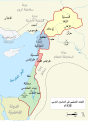
Čeština: Politická mapa Blízkého východu v roce 1135. Deutsch: Die Levante, 1135, zwischen den Ersten und Zweiten Kreuzzügen. Kreuzzugsstaaten sind mit einem roten Kreuz gekennzeichnet Eesti: Lähis-Ida (1135) Español: Oriente Próximo en 1135, entre la primera y segunda cruzadas. Esperanto: Politika mapo de Levantenio dum 1135, inter la krucmilitaroj unuaj kaj duaj. Français : Carte politique du Proche-Orient en 1135, entre la Première et la Seconde Croisades. les États latins d'Orient sont marqués d'une croix rouge. Italiano: Carta politica del Vicino Oriente nel 1135. Magyar: A Közel-Kelet térképe 1135-ben. Polski: Mapa polityczna Bliskiego Wschodu w roku 1135, w okresie II krucjaty. Ελληνικά: Πολιτικός χάρτης της Μέσης Ανατολής το 1135, ανάμεσα στην πρώτη και τη δεύτερη Σταυροφορία Македонски: Политичка карта на Блискиот Исток во 1135 г. Крстоносните држави се означени со црвени крстови. Русский: Карта Ближнего Востока в 1135 г. Српски / srpski: Politička karta Bliskog Istoka 1135. godine, između Prvog i Drugog krstaškog pohoda. Krstaške države su označene crvenim krstom. ქართული: ახლო აღმოსავლეთი 1135 წელს ไทย: แผนที่ตะวันออกกลาง (คศ. 1135) ระหว่างครูเสดครั้งที่ 1 และครั่งที่ 2 中文: 一副关于1135年近东地区局势的地图,标注红色十字的为十字军国家 العربية : الدويلات الصليبية والدول الإسلامية المجاورة لها في الفترة بين الحملتين الصليبيتين الأولى والثانية. فارسی : نسخه فارسی |
||
| Datum | 7 maart 2008 (originele uploaddatum) | ||
| Bron | Geen machineleesbare bron opgegeven. Eigen werk aangenomen (gebaseerd op auteursrechtclaims). | ||
| Auteur | Geen machineleesbare auteur aanwezig. Op basis van auteursrechtclaims wordt auteur Stuntelaar~commonswiki aangenomen. |
References
- Bjorklund, Oddvar; Holmboe, Haakon; Rohr, Anders (1970) Historical Atlas of the World, Barnes & Noble, NY, SBN: 389-00253-4.
- Asia Minor and the Crusader states, c. 1140 from Findlay, Alexander G. (1849) Classical Atlas of Ancient Geography.
- Map of the Crusader states from Muir's Historical Atlas (1911)
- Eine Karte aus Putzgers, Historischer Schul-Atlas 39. Auflage. 1917. Tafel 16.
Other versions
[]
-
 العربية
 -
 català
 -
 čeština (Tsjechisch)
 -
 Deutsch (Duits)
 -
 English (Engels) (original)
 -
 Esperanto (Esperanto)
 -
 español (Spaans) (1)
 -
 español (Spaans) (2)
 -
 eesti (Estisch) (PNG)
 -
 français (Frans) (1)
 -
 français (Frans) (2)
 -
 Bahasa Indonesia
 -
 italiano (Italiaans) (PNG)
 -
 magyar (Hongaars)
 -
 日本語 (Japans) (PNG)
 -
 Nederlands (Nederlands)
 -
 polski (Pools)
 -
 português (Portugees)
 -
 македонски (Macedonisch)
 -
 русский (Russisch)
 -
 Ελληνικά (Grieks)
 -
 հայերեն (Armeens)
 -
 ქართული (Georgisch) (PNG)
 -
 中文 (Chinees)
 -
 العربية (Arabisch) (PNG)
 -
 فارسی (Perzisch) (PNG)


-ka.png)


See also
Licentie
Ik, de auteursrechthebbende van dit werk, maak het hierbij onder de volgende licentie beschikbaar:

|
Toestemming wordt verleend voor het kopiëren, verspreiden en/of wijzigen van dit document onder de voorwaarden van de GNU-licentie voor vrije documentatie, versie 1.2 of enige latere versie als gepubliceerd door de Free Software Foundation; zonder Invariant Sections, zonder Front-Cover Texts, en zonder Back-Cover Texts. Een kopie van de licentie is opgenomen in de sectie GNU-licentie voor vrije documentatie. |
| Dit bestand is gelicenseerd onder de Creative Commons-licentie Naamsvermelding-Gelijk delen 3.0 Unported | ||
| ||
| Deze licentietag is toegevoegd aan dit bestand in verband met de GFDL licentie-update. |
Bestandsgeschiedenis
Klik op een datum/tijd om het bestand te zien zoals het destijds was.
| Datum/tijd | Miniatuur | Afmetingen | Gebruiker | Opmerking | |
|---|---|---|---|---|---|
| huidige versie | 7 jul 2010 23:39 | | 978 × 1.330 (654 kB) | wikimediacommons>Malus Catulus | Converted text to path |
Bestandsgebruik
Dit bestand wordt op de volgende pagina gebruikt:
